
Key Takeaways
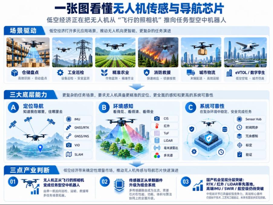
- Low-altitude economy is turning drones from flying cameras into task-oriented aerial robots that must work inside warehouses, buildings, farms, fire scenes, and future eVTOL corridors.
- That shift moves sensor value from a single component to scenario adaptability: an IMU, RTK receiver, image sensor, thermal core, LiDAR, and radar working as one calibrated, verifiable system.
- Warehouses come first because GNSS is unavailable indoors, so continuous localization falls to IMU, VIO, UWB, or LiDAR SLAM, backed by ToF or short-range LiDAR for close-quarters safety.
- Industrial inspection is the shift from “seeing” to “evidence”: global-shutter and HDR CIS plus thermal imaging and LiDAR, not higher pixel counts alone.
- Chinese suppliers have the strongest footing in GNSS/RTK, thermal imaging, LiDAR ranging, mmWave modules, and multispectral payloads; the hardest gaps remain tactical-grade IMU and aviation-certified redundant sensing.
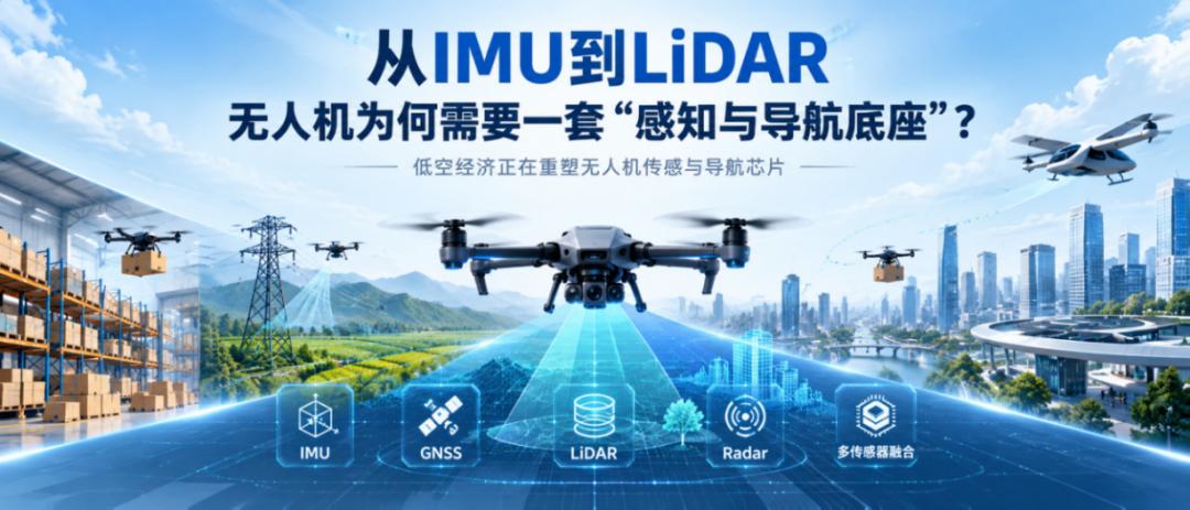
When drones enter complex environments, sensing and navigation chips stop being individual components and become system-level capability. This is the third article in a series on the drone chip value chain – after RF and compute, the missing piece is the sensing and navigation foundation.
Introduction: From RF to Brain, Drones Still Lack a Sensing Foundation
Two earlier articles in this series looked at value chains that the low-altitude economy is reshaping. The first covered drone communication and RF links: as drones move from consumer aerial photography to industrial inspection, logistics delivery, swarm operations, and longer low-altitude flights, RF front ends, power amplifiers, filters, low-noise amplifiers, and satellite/GNSS components stop borrowing from the phone, Wi-Fi, and telecom supply chains and start developing drone-specific requirements. The second covered compute and control: from flight controller MCUs to mission processors, AI compute platforms, and edge modules, there is no single “brain” inside a drone that unifies every task. Flight control, path planning, vision, gimbal control, payload processing, and edge AI are handled by compute chips at different levels.
If RF answers “can it connect and how far,” and compute and control answer “how does it calculate and how does it fly,” then the low-altitude economy raises a third question: can the drone see its environment, know where it is, and decide whether it can move closer to the target?
That is the third value chain this article covers: drone sensing and navigation chips.
A consumer drone flying in a park, over a beach, or above a mountain mainly needs to fly stably, shoot clearly, and transmit reliably. What the low-altitude economy actually has to solve is not flying a few more kilometers in open sky or producing prettier aerial footage, but getting drones into real industrial sites that were previously hard to automate: warehouses, building facades, solar farms, oil and gas terminals, farmland, fire scenes, urban communities, and future eVTOL corridors.
These places are not built for flying. A warehouse has no stable GPS, yet the drone must take inventory among tall racks and narrow aisles. Glass curtain walls reflect glare, so facade inspection drones must fly close to the surface while separating reflections, shadows, and actual cracks. Power, oil and gas, and solar inspection is not about taking a few photos but about identifying hot spots, thermal defects, leak risks, and structural change. Agricultural spraying is not just putting chemicals in the air but judging crop growth, terrain relief, and spray distance. Fire and rescue face night, smoke, high heat, and occlusion, where ordinary visible-light cameras quickly fall short. Urban logistics is hardest not in reaching the neighborhood but in the last few dozen meters – identifying the drop point, avoiding people, vehicles, and tree lines, and completing delivery safely. By the time you reach eVTOL, sensing and navigation is not about “does it work well” but about redundancy, reliability, and certifiability.
So this article focuses on the sensing and navigation foundation a drone needs in complex scenarios: IMU, gyroscopes, accelerometers, magnetometers, and barometers; GNSS, RTK, and GNSS/INS integrated navigation; CIS image sensors and infrared thermal imaging; ToF/dToF, LiDAR, and millimeter-wave radar; multispectral and ambient light sensors and active light sources; and VIO, LiDAR SLAM, sensor hubs, and multi-sensor fusion. In the drone field, sensors are moving from isolated component upgrades toward sensing and navigation systems that can be mass-produced, calibrated, verified, and run long-term.
Where There Is No GPS, Sensing Is Tested First
The first real low-altitude applications happen in lower, narrower, harder-to-fly places: between warehouse racks, inside underground pipe networks, in sewers, in tanks, and in enclosed plant areas.
IKEA’s work with Verity is a typical example. As of 2024, IKEA had more than 250 drones operating at 73 locations in 9 countries for inventory checks, moving toward 24/7 warehouse operation. The case shows that drones can enter rack-dense, narrow-aisle, human-robot-mixed warehouse environments and continuously turn physical inventory into a computable data asset.
The On Running and Verity case, and the GEODIS and Gather AI case, go further: warehouse drones have moved from one-off counting tools to continuous inventory visibility systems. Verity says its system performs millions of fully autonomous inventory checks per month across more than 80 warehouses, while Gather AI’s customer case shows GEODIS using the platform to guide operators directly to the last known position of a misplaced pallet.
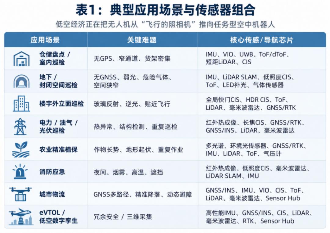
The technical difficulty in warehouses breaks into three layers. The first is missing localization: GNSS and RTK are unusable indoors, so the drone needs IMU, VIO, UWB, or LiDAR SLAM for continuous positioning.
The second is close-quarters safety: dense racks and narrow aisles mean ordinary cameras struggle to give reliable distance, so ToF/dToF, short-range LiDAR, or ultrasonic sensing fills the gap.
The third is identification and verification: counting does not end at seeing a rack – barcodes, RFID, slot status, and exception positions must be confirmed, which brings CIS, global-shutter CIS, and scan modules into the system.
This is also why warehouse counting tests sensing and navigation chips first rather than flight control alone. These scenarios have neither open sky nor a stable GNSS signal.
The drone must use its own sensors to judge attitude, velocity, distance, and positional drift: the IMU handles short-term attitude and motion estimation, CIS identifies racks, barcodes, and slots, ToF or short-range LiDAR judges distance to racks, walls, and obstacles, and VIO and SLAM help the drone build a sense of position where there is no GPS.
Underground and confined-space inspection pushes the problem further. In Flyability Elios 3 sewer inspection work with Veolia, drones reduce inspection cost and time while improving worker safety. Academy Geomatics used the Elios 3 for UK underground sewer mapping, achieving zero personnel entry into confined spaces at roughly 20 mm accuracy. There is no GNSS, lighting is not guaranteed, space is narrow, and hazardous gas may be present.
This architecture also brings supply-chain competition down to a more practical level. In IMU/MEMS, Bosch, TDK, ADI, and Epson remain common international suppliers for warehouse drones and robots, with advantages in stability, ecosystem, and high-end product depth. Chinese suppliers including Xindonglianke, QST, Senodia, MEMSensing, and Memsic are climbing from consumer electronics and robotics into industrial-grade applications.
In ToF/dToF, ST, ams OSRAM, Melexis, and TI have mature devices and ecosystems, while domestic players more often enter through 3D vision and robotics, with Orbbec and ADAPS holding transferable foundations. In LiDAR and short-range ranging, Ouster, RIEGL, and LightWare represent international options, while Benewake, Livox, Hesai, and RoboSense already have a base in low-cost, lightweight, robot-grade LiDAR and ranging modules.
Industrial Inspection: From Camera Tool to Detection System
Industrial inspection was one of the first scenarios where drones proved commercial value, but a key change is underway: drones are no longer just flying over to take a few photos. They are becoming part of remote detection, anomaly identification, and asset digitization.
The distinction matters. Aerial photography emphasizes the image; inspection emphasizes evidence. Does a building facade have cracks, seepage, or debonding? Is power equipment overheating? Do solar modules have hot spots? Is there leak risk at oil and gas facilities? Is a refinery stack temperature abnormal? A visible-light camera alone cannot answer these. Industrial inspection requires the drone to turn “seeing” into “judgeable data,” which is what drives demand for CIS, infrared thermal imaging, LiDAR, GNSS/RTK, GNSS/INS, and millimeter-wave radar.
Facade inspection is the most underestimated scenario. On the surface it just means flying the drone along a wall; in practice, glass curtain walls, glare and backlight, deep shadow, repeating texture, high-altitude wind, and close-in flight simultaneously challenge imaging, localization, and obstacle avoidance.
This is where industrial CIS starts to diverge from consumer cameras. Facade inspection needs more than higher resolution – it needs more stable machine-vision input. Global-shutter CIS reduces image distortion from high-speed motion or airframe vibration; HDR CIS handles glare, backlight, and deep shadow; low-light or NIR-enhanced CIS serves night, shadow, and weak-light conditions; high-resolution CIS and zoom modules identify cracks, seepage, and facade defects; and ToF, LiDAR, and millimeter-wave radar judge distance to the wall to reduce close-flight risk.
The supply chain picture becomes clear here too. Sony, onsemi, OMNIVISION, Teledyne e2v, and Gpixel remain important suppliers of industrial CIS and machine-vision image sensors, while domestic players include SmartSens, Gpixel Changchun, and GalaxyCore. The gap is not only in single-chip parameters but in modules, lenses, ISPs, interfaces, calibration, and long-term supply capability. If consumer drones value “shooting well,” industrial drones value “seeing stably, seeing accurately, and being usable by algorithms,” so CIS competition shifts from pixels and image quality toward global shutter, HDR, low light, NIR/SWIR, and module ecosystems.
Power, oil and gas, and solar inspection further amplify the value of infrared thermal imaging. Visible light shows appearance, but many industrial defects first manifest as temperature change. Abnormal heating in power equipment, hot spots in solar modules, anomalies at oil and gas facilities, and changes in pipeline condition are all hard to judge from ordinary imagery alone.
This is why infrared thermal imaging becomes an important payload for industrial drones. Infrared detectors and thermal camera cores identify hot spots, solar defects, and fire points; high-resolution CIS and telephoto modules identify structural detail at distance; GNSS/RTK, GNSS/INS, and IMU support repeat inspection and route comparison; LiDAR and photogrammetry establish the spatial relationships of towers, pipelines, and solar arrays; and millimeter-wave radar provides redundant sensing in rain, fog, dust, and complex weather.
In real projects, this combination is no longer conceptual. PG&E’s remote power asset inspection with Skydio shows power inspection shifting from “a pilot brings a drone to the site” to “a drone dock plus remote operations.” The corresponding sensing and navigation demand includes high-reliability IMU, GNSS/RTK, visual obstacle avoidance, thermal imaging, zoom CIS, and multi-sensor fusion.
Oil, gas, and refinery scenarios emphasize anomaly detection and remote operation even more. Chevron’s autonomous oil and gas terminal inspection with Percepto already combines AI remote inspection, methane leak detection, optical gas imaging, and real-time AI identification, while Delek US’s BVLOS autonomous refinery inspection with Percepto covers pipelines, floating-roof tanks, stack temperature, leaks, and safety rounds with automatic anomaly alerts. Industrial drone sensing systems are therefore no longer just visible-light cameras; they combine CIS, infrared detection, gas imaging, GNSS/INS, and obstacle-avoidance sensors.
Solar is the same story. Large solar plants cover big areas with many modules, manual inspection is inefficient, and hot spots and module defects demand more stable data collection. EGAT’s monitoring of a large floating solar plant with Percepto, covering roughly 250 acres of water-based solar, illustrates the demand large energy assets place on hot-spot detection, panel defect identification, and cable and transformer inspection. Such scenarios pull on infrared thermal imaging, CIS, RTK positioning, automatic route planning, and multi-sensor data management.
Looking at the supply chain, infrared thermal imaging is an area where Chinese manufacturers have a relatively strong base. International suppliers include Teledyne FLIR, Lynred, Leonardo, and Hamamatsu, while domestic players include Guide Infrared, Raytron, HIKMICRO, and Fujirui. The domestic infrared chain is strong, with detectors, camera cores, and industry solutions already in place. In LiDAR, high-end surveying still looks to RIEGL, Ouster, and LightWare, but Livox, Hesai, RoboSense, and Benewake have openings in cost-sensitive, robot-grade, and industrial inspection scenarios. In GNSS/RTK, u-blox, Septentrio, Trimble, and NovAtel remain the international representatives, while Unicore, ComNav, Huada Beidou, and BYNAV represent the domestic high-precision positioning chain.
In industrial inspection, millimeter-wave radar plays more of a safety-redundancy role. It will not replace CIS and LiDAR, but in rain, fog, dust, strong light, night, and low-visibility conditions it can supplement distance, speed, and obstacle information. For drones flying close to buildings, solar arrays, power facilities, or oil and gas equipment, redundant sensing is not a nice-to-have – it is the precondition for moving automated inspection from demonstration to routine operation.
Industrial inspection therefore drives a sensor combination rather than a single-chip substitution. Supplier competition shifts from single-sensor parameters to whether a device can be integrated into a stable, calibratable, long-running industrial inspection system.
From Spraying and Rescue to Delivery: Drones as Task Systems
If industrial inspection turns drones from shooting tools into detection tools, agriculture, firefighting, and urban logistics push them further into task-oriented systems. What they share is that the drone must judge, act, and feed back within a complex environment.
Agricultural drones were long understood as sprayers, with value seemingly coming from tank capacity, endurance, spray width, and operating efficiency. Precision agriculture is changing that logic. The drone no longer just drops pesticide, fertilizer, or seed from the air; it must judge crop growth, find early signs of pests and disease, identify terrain relief, control spray distance, and keep data comparable across different lighting conditions. The upgrade path is not spraying more but becoming a crop data collection and precision operation platform.
This is why multispectral sensors and ambient light sensors enter the drone. A visible-light camera can capture a field, but crop growth, leaf condition, early pest and disease signals, and nutrient status are often identified through reflectance differences across bands. Multispectral or hyperspectral payloads provide crop state data, while ambient light and spectral calibration sensors correct for differences across time, weather, and lighting. Without that calibration, data from the same field collected in the morning, in the afternoon, on a clear day, and on a cloudy day is hard to compare directly.
The value of RTK and IMU in agriculture is equally direct. Precision agriculture depends on repeatable routes and operational accuracy; if a drone sprays one day and rechecks the next with large position error, data and operations cannot close the loop. GNSS/RTK handles centimeter-level positioning, the IMU handles attitude and short-term motion estimation, and barometers, LiDAR, ToF, or millimeter-wave radar handle terrain following and altitude hold. Mountains, hills, orchards, and terraces are not flat fields – the drone must know its distance to the ground, canopy, or crop to control spray distance and flight safety.
In DJI Agriculture cases, partners use multispectral scouting to identify weeds in the field and send prescription maps to Agras drones for precision spraying. The orchard solution demonstrated by XAG and Bayer emphasizes AI and 3D flight modes for fruit-tree work on complex terrain such as mountains, hills, and terraces, using three-dimensional high-definition maps to identify tree positions and sizes before precise operation.
In the supply chain, international representatives for multispectral payloads include MicaSense, Sentera, and the DJI multispectral ecosystem, while domestic names to watch include Changchun Yuchen and Optosky together with the DJI Agriculture ecosystem. In RTK/GNSS, u-blox, Trimble, and Septentrio are international representatives, while Unicore, ComNav, Huada Beidou, and BYNAV have strong localization. Terrain sensing opens opportunities for LiDAR, millimeter-wave radar, and ranging module suppliers such as Benewake, NanoRadar, and Livox.
Firefighting and emergency rescue follow different logic. Agriculture is about understanding crops; firefighting is about still getting usable information when you cannot see clearly. Night, water, fire scenes, hazardous chemical incidents, smoke, high heat, occlusion, and complex building structures quickly defeat ordinary visible-light cameras.
The Oklahoma City police and fire departments use thermal-capable Skydio drones to search large areas quickly in scenarios such as water rescue, while the Southern Manatee Fire Rescue HazMat team uses DJI drones with thermal and zoom cameras to assess hazardous material scenes, helping the team confirm dangerous conditions from a safe distance.
Compared with ordinary inspection, fire and rescue places stronger emphasis on redundancy in the sensing system: visible light, infrared, radar, LiDAR, and inertial navigation must cover for one another. The combination of infrared, radar, LiDAR, and IMU determines whether a drone can act as a remote sensing node in a dangerous scene.
Urban logistics faces the same problem: reliable perception in a complex environment. Drone delivery is hard not in flying from point A to point B but in the last few dozen meters. It must identify the landing point, avoid people, vehicles, trees, cables, and temporary obstacles, handle GNSS multipath from urban canyons, and complete precise delivery or a safe landing. Urban logistics is not a single navigation problem but a system problem of continuous localization, terminal identification, dynamic obstacle avoidance, and redundant safety.
Cases including Wing with Walmart, Zipline, and Matternet with the NHS and Apian show that drone delivery has entered commercial validation and even scaled operation. Its core capabilities are long-range navigation, route redundancy, precise delivery and landing, health monitoring, and high-reliability operation. In medical delivery in particular, early commercial scenarios are often not takeout food but hospital samples, medicines, and critical medical supplies, because they are time-sensitive, high-value, and follow relatively fixed routes. Urban logistics therefore pulls on GNSS/INS, IMU, VIO, CIS, ToF, LiDAR, millimeter-wave radar, and sensor hubs simultaneously.
eVTOL and Low-Altitude Digital Twins: The High-End Arena
If warehousing, inspection, agriculture, and logistics have already moved drone sensing and navigation from single components to combined capability, eVTOL and low-altitude digital twins push that competition to the system level.
What eVTOL changes first is the safety requirement. Ordinary industrial drones can optimize around mission efficiency, but passenger-carrying low-altitude transport demands long-term reliability, multiple redundancy, detectable faults, and verifiable systems, and may eventually involve airworthiness certification. The sensing and navigation needs of eVTOL come down to highly reliable attitude and positioning, complex takeoff and landing with obstacle detection, altitude, airspeed, and environmental judgment, and redundancy with health monitoring.
High-performance IMU and GNSS/INS must provide reliable position, velocity, and attitude information; CIS, LiDAR, and millimeter-wave radar serve takeoff, landing, obstacle avoidance, and surrounding environment perception; barometric, airspeed, and environmental sensors supplement flight state judgment; and sensor hubs and fusion algorithms turn multiple sensor streams into a verifiable system state.
This also separates supply-chain tiers. In high-performance IMU/INS, international vendors such as Honeywell, ADI, Safran, VectorNav, and SBG retain advantages, while domestic manufacturers including Xindonglianke are climbing, though tactical-grade and aviation-grade applications still need longer validation cycles. In highly reliable radar and LiDAR, Echodyne, Ainstein, RIEGL, and Ouster represent mature international routes; domestic LiDAR and millimeter-wave radar have a base but airworthiness-grade applications still need system validation cycles. Infrared, SWIR/MWIR, and fusion follow similar logic: domestic infrared is strong in uncooled thermal imaging, but high-end SWIR/MWIR, aviation-grade redundant sensing, and certification ecosystems remain weak points.
Low-altitude digital twins raise the bar from another direction. They make drones the entry point for three-dimensional urban data collection, turning buildings, roads, pipelines, green space, and low-altitude corridors into computable models. To do that, the drone needs LiDAR to collect point clouds, high-resolution CIS to collect texture and imagery, RTK and GNSS/INS for georeferencing, IMU for attitude compensation, and time synchronization modules and sensor hubs to keep multi-sensor data consistent.
Here too, supply-chain competition is not simple hardware stacking. In surveying LiDAR, RIEGL, Ouster, and the Trimble ecosystem still represent high-end surveying capability, while Livox, Hesai, and Benewake offer cost-performance and engineering opportunities. In RTK/GNSS/INS, Trimble, Septentrio, u-blox, and SBG are the international representatives, while CHC Navigation, Hi-Target, ComNav, Unicore, and BYNAV form a relatively mature domestic high-precision positioning chain. In aerial survey CIS and cameras, Sony, Gpixel, and Teledyne e2v retain advantages in high-end imaging, and domestic players such as Gpixel Changchun and Sunny Optical need continued accumulation across sensors, lenses, modules, and calibration.
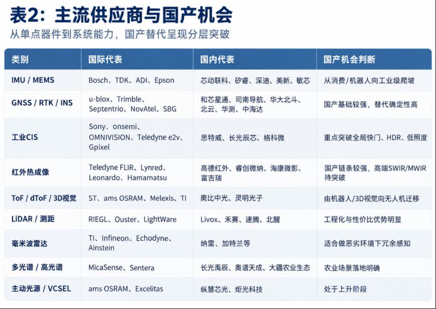
Overall, the opportunity for domestic sensors in drones is not simple full substitution but layered breakthrough. The first layer, where a strong base already exists, includes GNSS/RTK, infrared thermal imaging, LiDAR and ranging, millimeter-wave radar modules, and multispectral payloads. The second layer, still climbing, includes high-performance MEMS IMU, industrial-grade CIS, ToF/dToF and 3D vision, and active light sources and VCSELs. The third layer, requiring long-term breakthroughs, includes tactical-grade and aviation-grade IMU, highly reliable GNSS/INS, high-end SWIR/MWIR detectors, eVTOL redundant sensing systems, and aviation-grade sensor certification with long-term reliability data.
In the early low-altitude economy, opportunities for domestic manufacturers are most likely in segments that are cost-sensitive, clearly scoped, and require supply-chain localization – agriculture, inspection, surveying, warehousing, and parts of urban governance. In eVTOL, aviation-grade integrated navigation, and high-end industrial sensing systems, competition returns to reliability, certification, ecosystem, and system validation. Ultimately, the value of sensing and navigation chips is not in isolated parameters but in whether they can enter a sensing and navigation system that can be mass-produced, calibrated, verified, and run long-term.
Sensing and Navigation Supply Chain at a Glance
| Sensor category | International suppliers | Chinese suppliers | Primary drone use |
|---|---|---|---|
| IMU / MEMS | Bosch, TDK, ADI, Epson | Xindonglianke, QST, Senodia, Memsic | Attitude and short-term motion estimation |
| GNSS / RTK / INS | u-blox, Septentrio, Trimble, NovAtel | Unicore, ComNav, Huada Beidou, BYNAV | Centimeter positioning and route repeatability |
| Industrial CIS | Sony, onsemi, OMNIVISION, Teledyne e2v, Gpixel | SmartSens, Gpixel Changchun, GalaxyCore | Global-shutter, HDR, low-light machine vision |
| Infrared thermal | Teledyne FLIR, Lynred, Leonardo, Hamamatsu | Guide Infrared, Raytron, HIKMICRO, Fujirui | Hot spots, thermal defects, fire points |
| ToF / dToF | ST, ams OSRAM, Melexis, TI | Orbbec, ADAPS | Close-quarters distance and 3D vision |
| LiDAR / ranging | Ouster, RIEGL, LightWare | Benewake, Livox, Hesai, RoboSense | Point clouds, terrain following, obstacle avoidance |
| mmWave radar | Echodyne, Ainstein | NanoRadar and others | Redundant sensing in rain, fog, and dust |
Have questions about this article? Feel free to contact us at [email protected] — we’re happy to help!
Frequently Asked Questions
Why do drones need a sensing foundation rather than better cameras?
A better camera improves the image, but inspection needs evidence and autonomous flight needs position. IMU, RTK, LiDAR, and thermal sensing convert what a drone sees into judgeable data and let it localize where GPS is unavailable.
Which sensors matter most when GPS is unavailable indoors?
IMU, VIO, UWB, and LiDAR SLAM provide continuous localization, while ToF/dToF or short-range LiDAR handles close-quarters distance to racks and walls. CIS then identifies barcodes, slots, and exception positions.
What does eVTOL change about drone sensing requirements?
Passenger-carrying low-altitude transport demands long-term reliability, multiple redundancy, detectable faults, and verifiable systems, moving toward airworthiness certification. That favors tactical and aviation-grade IMU, redundant GNSS/INS, and certified sensing ecosystems.
Where do Chinese sensor suppliers have the strongest position?
The strongest base is in GNSS/RTK, infrared thermal imaging, LiDAR and ranging, millimeter-wave radar modules, and multispectral payloads. High-performance MEMS IMU, industrial CIS, and ToF/dToF are climbing; tactical-grade IMU and aviation-certified sensing remain long-term gaps.
Why does millimeter-wave radar matter for inspection drones?
It acts as safety redundancy rather than a replacement for CIS and LiDAR. In rain, fog, dust, strong light, and low visibility it still supplies distance, speed, and obstacle information, which is what moves automated inspection from demonstration to routine operation.
About Aomway
Aomway is a technology company specializing in drone and FPV equipment, publishing in-depth analyses of motor control, embedded hardware, and open-source robotics projects. With over 15 years of industry experience, Aomway covers the full spectrum from flight controllers and FPV goggles to thermal imaging cameras and long-range datalinks for the global drone community.